Monday, September 16, 2019

Days 13 & 14, September 12 & 13, 2019 -- Northwest Mountains Expedition

Day 13, September 12, 2019 – Wall Drug
Unfortunately, the weather still isn’t cooperating. It’s disappointing not to be able to enjoy the sights of Mount Rushmore or the Badlands, but we did head to Wall Drug. Wall, SD, is such a cute little town, and there’s a fascinating story of how one couple’s idea of putting up hundreds of signs along the roadway
offering free ice water to travelers put the town on the map.  What is now almost a block-long “Drug Store” reflects both the past and the present as well as the unique history of the Black Hills.  We spent a lot of time reading newspaper articles from all over about what was done here, and we enjoyed the chapel, the many statues and paintings of Indians, saloon girls, jackalopes, cowboys, covered wagons, wild critters from this area, the many opportunities to shop for trinkets and partake in their free ice water, 5 cent coffee and, of course, yummy ice cream!

This evening we enjoyed a scrumptious dinner at the famed Firehouse Brewery and Winery … and now it’s time to repack and get ready to head for home tomorrow morning.


Day 14, September 13, 2019 -- Homeward Bound

I'm really not a superstitious person, but today is Friday the 13th and maybe, just maybe that had something to do with the adventure we had coming home!!

Leaving Rapid City going east on I-90 is a pleasing ride through varied terrains that range from hills and deeper valleys and ravines to gently rolling hills of grasslands dotted with black angus or herferds into the relatively flat acres and acres of bales scattered in the hay fields or fields of sorghum, soybeans or some corn.  Both South Dakota and southern Minnesota have many wind farms taking advantage of the seemingly constant winds to provide us with energy.


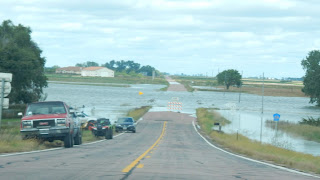
About 70 miles west of Sioux Falls, by Mitchell, I-90 is closed due to flooding.  Google maps was very accurate and easily got us around this closure. About 20 miles further, I-90 was closed again due to flooding.  This time, as we were forced to exit the freeway, the road to the north was closed due to flooding; the road to the south was closed due to flooding; and the dirt road going east to Sioux Falls was closed due to flooding. And there are no detour instructions!  So we head back toward Mitchell, attempting to find a road north of the freeway that will allow us to continue east.  We were stopped on every road we tried -- flooding -- and Google had no idea!  We did make it back to Mitchell, where we learned that they have had 9-12 inches of rain this week, which not only meant every river and creek was over its banks, but many homes experienced flooded basements as well. 


After trying to get some news on open roads, we ventured out again to get through to the east.  After several hours, we're getting low on gas and needed to back track to Madison -- continuing to be stopped on most roads.  It was a maze, and we were batting zero!  Well --- we finally did arrive in Madison for gas; and after four hours of searching, we had driven beyond the flooding and came home via the back roads of Minnesota.  We arrived home safe and sound and totally exhausted at 11 p.m. after meandering through that 4-hour detour.  How's that for topping off our Northwest Mountain Expedition??
There was a full moon tonight, called a Micromoon or Minimoon
because the moon is at the farthest point from earth


Thursday, September 12, 2019

Day 12, September 11, 2019 -- Northwest Mountains Expedition


Day 12, September 11, 2019 – The Black Hills

Iron Star by John Lopez
Well, the weather did not cooperate with us today.  We started out toward the Wind Cave with a stop in Hill City.  Here we enjoyed the creative scrap metal art sculpture of John Lopez’s Iron Star.  I’m not normally a fan of scrap metal art, but this horse is really a beautiful masterpiece of infused scrap with bronze pieces, barbed wire, chain links, tools which include a fork and shovel, silverware, etc.  And within the sculpture itself are five artfully placed equine bronze sculptures and a man’s face. And then there’s a colt with its beautiful mane of nails plus wrenches, silverware, etc.  Both pieces are quite amazing.

Needles Highway
The Needle
After a bit of shopping, we decided that because it’s not raining, we might be able to see Mount Rushmore even though the clouds are very low.  So we drove the beautiful windy road up the mountain, only to find that above 5,000 feet the visibility was nill!  Being flexible, Plan C was to drive through the Needles Highway, hoping that, by the time we get to the top, the clouds will have lifted a bit.  Unfortunately, they lifted very little. We were able to observe the narrow tunnel (8 feet wide, 10 feet 10 inches tall carved through a rock formation at 6,200 feet above sea level) and the giant needle-like columns at the peak; but as we twisted and turned both up and down the mountain, clouds prevented us from enjoying the beautiful vistas of the area that I know exist! 

Now we are at Plan D – It’s just, just starting to rain; we head toward the Crazy Horse Memorial to get a glimpse of the work being done. This massive project has been undertaken to preserve the culture, tradition and living heritage of all North American Indians.  While they have been working on the gigantic carving on the side of the mountain of Crazy Horse galloping on his horse for about
Crazy Horse Carving taken in the rain!
50 years, there is still a lot of carving to be done.  This is a privately sustained project with money coming from admissions and donations to the Memorial.  It certainly is an ambitious project and should be amazing when it is completed. Unfortunately, once again the clouds above 5,000 feet prevent us from seeing the Memorial, though we can get an idea of what it will look like when finished from an iron replica near the road.

On to Plan E – It’s getting to be time for lunch, so we find a cute little burger place in the town of Custer.  A unique feature of this quaint Western Town of Custer is that on what seems to be every corner, a creatively painted statue of a bison reminds us of the importance this large creature played in our Nation’s history.  Now it began to pour rain as we run into the cafĂ©, it poured while we ate lunch, and it drenched us as we ran back to the car.  But we did find out during lunch that the Wind Cave is closed to tours until October due to a problem with their elevators.  So …….

On to Plan whatever – Guess what?  There are a lot of wineries in the Black Hills, and we chose to enjoy wine tasting at two of them in Hill City – Twisted Pine Winery and Naked Winery.  It made for a fun, relaxing afternoon enjoying some very nice wines of the area.  Coming back to our “home”, we had time to relax and visit, then go out for a leisurely, delicious dinner at a local Irish Pub and reflect on this amazing expedition we’ve been on for almost two weeks now.


Wednesday, September 11, 2019

Day 11, September 10, 2019 -- Northwest Mountain Expedition

Day 11, September 10, 2019 –Little Big Horn National Monument and Devil’s Tower

This morning we left Red Lodge, heading north to Billings and then down to the Little Big Horn National Monument.  This is the location where the Sioux and Northern Cheyenne forces led by Sitting Bull and Crazy Horse overwhelmed General Custer and his cavalry on June 25, 1876.  The tribes were fighting to preserve their traditional way of life as nomadic buffalo hunters. The US Army was carrying out the Grant Administration’s orders to remove the Lakota Sioux and Cheyenne to the Reservation in Dakota Territory.  As one goes along the ridge of the battlefield, white markers indicate the places of fallen soldiers; red markers indicate the believed places of fallen Native American warriors.  We viewed a video on the strategic actions of the battle, then listened to a Park Ranger explain what brought about the battle – why the cavalry was there and why the Indian Nations were gathered there.  It was very detailed and informative –Brave men on both sides fought and died for what they believed in on these grounds; a sad time in our nation’s history.
From here we took the back roads to Devil’s Tower, Wyoming, first going east through the rolling hills and ravines of the high plains of the Crow Indian Reservation, then through the Custer National Forest. We again see a lot of cattle grazing on these plains, scattered dots of green evergreens, yellow grasses and beautiful vistas that can be seen for miles from the tops of the hills.  Diane and I enjoyed the afternoon spotting antelope, attempting to get that most perfect picture (I never did get a great one!).  We saw many herds of antelope, too numerous to count – some larger herds, some smaller herds, some grazing, some lying down, some all by their lonesome!  We were giddy with excitement at seeing all these wild beauties!


Devil's Tower
Then, there in front of us, is the towering Devil’s Tower.  It rises up 1,267 feet from the base, making the summit 5,112 feet above sea level.  President Theodore Roosevelt declared it the First National Monument of the United States in 1906. The Indians found the name of this sacred place to be quite offensive and have made several attempts in recent years to change the name to Bear Lodge; however, that name change was never approved.  I found the American Indian Legends about this anomaly quite fascinating.  According to an article published in the March 21 2018 USA Today Travel Tips by Jason Chavis, these are two of those legends:

American Indian Legend

According to American Indian legend, the Devils Tower was created when six Sioux girls picking flowers in the forest were chased by bears. To save their lives, the Great Spirit lifted the ground underneath the girls. The bears attempted to climb the rock, but could not reach the girls at the top. Their attempts left scratch marks along the side of the monument.
Another American Indian tale tells of two Sioux boys who wandered away from their village. A giant bear named Mato attempted to eat them when Wakan Tanka the Creator raised the ground beneath them. Mato clawed at the side of the rock but then wandered off, forming Bear Butte near the Black Hills. Wanblee the Eagle lifted the boys off the monument and helped them back to the village.

We didn’t stay there very long – only long enough to breeze through the visitor’s center and take a few pictures – because by now it was raining quite hard.  A couple hours later we arrived at our home for the next few days in Rapid City, SD, having once again enjoyed a day of exploring and learning fascinating facts about our great country.  It would seem that driving for most of the day is actually more exhausting than all-day sightseeing, so after dinner it was another early to bed night knowing tomorrow will provide another opportunity to enjoy the mountains!
(From Devil’s Tower we heard of tornado watches; however, by time we arrived in Rapid City, the sun was shining. We learned later of the devastating tornado touchdowns near Sioux Falls. We’re paying for all those impacted by that tragedy.)


Day 10, September 9, 2019 -- Northwest Mountain Expedition


Day 10, September 9, 2019 – Once Again the Tetons, Yellowstone and Beartooth Pass

Elk Horn Arches, Jackson, WY
It’s not raining this morning and the sun is trying to peak through the cloud cover. As we leave Jackson, we stop at the town square where they have the unique elk horn arches on all four corners of the park.  It is quite a sight to see. These hundreds of naturally discarded elk horns were collected by the Boy Scouts over the years, and they are quite the attraction to this very Western town with its wooded sidewalks and Million Dollar Cowboy Bar!

Now we head back north through Jackson Hole again and up the eastern side of
Episcopal Chapel of the Transfiguration
Grand Teton National Park
Yellowstone.  The Grand Tetons stand about 12,000 feet tall, and we are able to get a decent view of their rugged peaks and glaciers, though it’s not as “perfect” as we’d like because of the clouds and haze!  The Episcopal Chapel of the Transfiguration is a tiny church with a beautiful view of the mountains through the all-glass front, with a rugged wooded cross placed strategically to remind us of who actually is the architect of all this beauty! The Chapel was constructed in 1925 to provide a home for the spiritual community, and people would gather from as far away as Jackson, 12 miles, in their horse and buggies. Services are still held there on Sundays during the summer.

Teton Mountains
Our Gypsy Guide App provided a very detailed explanation of the formation of Mount Moran, 12,605 feet.  What a fascinating process. I used to think that a rock is a rock is a rock (and I especially disliked them when I had to pick them out of the plowed fields as a child!!).  But that’s far from the truth.  Now I’m thinking I should have been a geologist.  I am so fascinated with these mountains!

Jackson Hole Valley
We take a little side trip 7,702 feet up the very narrow, windy road to the top of Signal Mountain. The view of the Absaroka Mountain range on the east side of Jackson Hole Valley and the valley itself is stunning.  It’s cold way up here, but the breathtaking vistas override any discomfort!

As we leave the Grand Tetons and come back into Yellowstone National Park, we cross the Continental Divide one last time at 7,988 feet.  After passing the lovely Lewis Lake, the third largest lake in Yellowstone which flows into the Pacific ocean, we make a quick stop at Lewis Lower Falls, another beauty in the forest .

Yellowstone Lake
We now drive 2 miles further to Yellowstone Lake which flows into the Gulf of Mexico.  The lake is up to 390 feet deep in some places and is the largest body of water in the Park and the largest freshwater lake above 7,000 feet in North America. It is approximately 50 miles long and 25 miles wide with 110 miles of shoreline. Not only that, but it’s very pretty.  What is really interesting is that along southwestern edge of the lake there are many hot springs and geysers steaming away on the shoreline. The contrast between the icy cold blue lake and the steaming hot geysers and springs is fascinating.

The Fishing Bridge located where the lake forms the Yellowstone River has quite the history. This was THE place to fish for cutthroat trout in the past. Today fishing is no longer allowed because someone introduced lake trout into the lake, a fish that feasts on the baby cutthroat trout, practically wiping out their entire population. And that resulted in an entire ecological effect on the animals who fed on them.  Conservationists are now attempting to eradicate the lake trout in hopes of returning the balance of nature to its original state.

Dragon's Mouth Springs
I think we could call today a Buffalo sighting day!  As we drive through Hayden Valley, we saw several lone buffalo … but stay tuned! 

Since the over 2 million acres of Yellowstone contains almost 300 geysers and over 10,000 hot springs, it wasn’t a surprise to find another treasurer. That bonus stop was at the Mud Volcano site.  It was stinky, but so fascinating to watch the Dragon’s Mouth Spring percolate mud as steam and gases explode through the water causing it to crash against the walls of a hidden cavern.  In other areas one wonders how the green and brown and yellow grasses can survive in this toxic hot spot. It’s an amazing area.

Yellowstone Canyon
Next, the Grand Canyon of Yellowstone.  The flow of the Yellowstone River is mostly responsible for shaping the 20 miles of canyon that creates a spectacular array of pillars, columns, reds and yellows. The width of the canyon varies from 1,500 to 4,000 feet wide and can be as much as 1,200 feet deep.  It also hosts the two biggest water falls in the park.  We drove along the Canyon Rim and viewed both the Upper and Lower Falls, with the Lower Falls tumbling down an impressive 308 feet, one of the highest falls in North America. It’s hard to imagine that just 25,000 years ago, most of Yellowstone was covered under 4,000 feet of ice!
Lower Falls
Yellowstone Canyon

Upper Falls
Yellowstone Canyon
After lunch at Canyon Village and our last bit of shopping for gifts, we continue our way through the east side of the Park through the beautiful Dunraven Pass, past Tower Falls to the turn into Lamar Valley.  As we drove through the valley we were greeted with hundreds of sightings of buffalo and a few Pronghorn antelope.  That was quite exciting!


We’re exiting the Park onto the northeast route to Beartooth Pass.  The twists and turns, turns and twists of the road up the mountain to 11,000 ft. and then back down is exhilarating – though I believe Diane might choose a different adjective!!  But we all agree on the simply gorgeous beauty of the mountains, the glaciers, the valleys, the crystal blue lakes nestled in the valleys, the rock formations, the green of trees struggling to survive and finally give up the higher we go. This is probably my favorite, must experience, mountain pass. It’s another Wow … Just WOW!


Scenes going through Beartooth Pass

Beartooth Pass

Some glaciers along Beartooth Pass

Our abode for the night is in Red Lodge, where we were greeted by a half dozen wild turkeys in the hotel parking lot.  We enjoyed another delicious dinner at a local bar and grill, now ready to plop into bed from exhaustion.  This driving and sightseeing certainly does wear us out.  But it’s a good tired … and we count our Blessings.


Monday, September 9, 2019

Day 9, September 8, 2018 - Northwest Mountains Expedition


Day 9, September 8, 2019 – Western Yellowstone and the Tetons

We wake up early once again in our excitement to explore more of Yellowstone and possibly see more wildlife.  More geysers are on the agenda for us to enjoy today, as Yellowstone hosts the most concentration of geysers than anywhere in the world.  A one-acre area has about 150 geysers!  So here are a few of the highlights of today –

Beryl Spring
Beryl Spring -– This is one of the hottest springs in Yellowstone, averaging 196 degrees F.  It is a large blue-green pool that loudly boils up to a height of 4 feet.  Pretty.

Gibbon Falls -– The falls drops down 84 feet in a gradual decent.  It’s a nice, peaceful spot along the Gibbon River.

Firehole Falls
Firehole Canyon Drive – The Firehole River gushes through a narrow canyon, creating a nice water falls to view.  Also, this area of the river is heated by the thermal activity from the upper geyser basin flowing into the river.  Because of this, the icy cold water of the river is actually very warm; and many people, including park staff, relish this area as a swimming hole.

Midway Geyser Basin – It’s beginning to rain hard now. But after
Runoff from
Excelsior Geyser Crater
waiting about 10 minutes, we were able to get a parking spot and made the trek up the boardwalk first to Excelsior Geyser Crater and then to the Grand Prismatic Spring.  Excelsior is the world’s largest geyser but is, for now, dormant. It is believed the powerful eruptions over the years damaged its delicate internal plumbing system, so now it boils as a productive hot spring most of the time. The Grand Prismatic is the largest hot spring in the United States and one of the three largest in the world. It is about 300 feet in diameter with beautiful deep azure blue water that is at a very hot 160 degrees F.  There is a dazzling array of colors around the edges of the spring due to the type of bacteria coming from the water.  While this was an awesome place to view, sadly the scenery and the quality of our pictures were very poor because of the rain.
Excelsior Geyser Crater
An attempt to capture the beauty
of the Grand Prismatic Spring
The beautiful colors around the
perimeter of the Grand Prismatic Spring


Old Faithful Inn
Old Faithful Inn -- What's a visit to this Yellowstone without a visit to it's iconic Old Faithful Inn?  It is a grand old building constructed in 1904. With it's massive log decor, large atrium surrounded by log railings on every level, massive stone fire place and it's hub-bub of activity of restaurants, gift shop and meeting place for guided tours, this is a beautiful reminder of the past mixed in with the modern present. Impressive.

Old Faithful Geyser
Old Faithful Geyser – Unlike other geysers, Old Faithful is still mostly faithful.  It is more or less consistent. Eruptions occur about every 75 minutes, give or take 15.  It shoots 3,700 to 8,400 gallons of boiling water in the air reaching an average height of 145 feet in just 15 to 20 seconds.  Eruptions typically last 1 ½ to 5 minutes.  Today Old Faithful did not disappoint, as it erupted at the precise posted time; and even our half-an-hour wait in the drizzling rain (we wanted a front-row seat among the several hundred viewers!) did not dampen our enthusiasm and awe in seeing the eruption!


Grand Tetons
We now head south and out of the Park to our evening’s destination in Jackson, WY. To get there we cross the Continental Divide two times before entering the Grand Teton National Park.  Being only 8 million years old, these mountains are the youngest range of the Rockies and are still growing. This 50-mile mountain range was formed by the movement of tectonic plates and is very unique because there are no foothills in front of it –- the mountains, without foothills, rise straight up out of the Jackson Hole valley. 


Even though the rain has stopped, the mountains were still shrouded in haze and clouds, so we did not see them in all their majesty.  But we still enjoyed the entire experience of driving through the most eastern route of the Park and were greeted by a herd of 200-300 bison at Oxbow Bend. It was a picture-taking frenzy! 

The Grand Tetons

All-in-all, it was another great day exploring the parks with their many wonders. We enjoyed dinner at Eleanor’s Again Bar and Grill in Jackson -– great food, many laughs, good company.  This evening we’re all totally exhausted –- early to bed, totally content with our many Blessings!